I think GPS is one of the most important 20th century innovation; the idea to be able to instantly know your perfect location on the earth (in terms of meters) without the need to do long and complex calculations, is something that just 50 years ago was “a dream”.
In these days we are so immersed in the technology that we do not care how it works and the GPS is a typical example of this: I press a button and my position appears in a map. Ok, simple. But how is this possible? This article will try to explain.
Basics
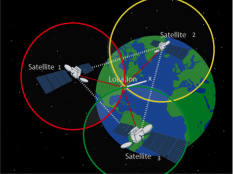
The Global Positioning System (GPS) word, nowadays identify many different systems (GPS in US, Galileo in Eu, GLONASS in Russia, …) all based on the same original idea developed by the U.S. Department of Defense in 1973 and consisting in a constellation of Satellites sending radio signals and a GPS receiver able to calculate the distance to each Satellite. Knowing the exact position of each Satellite and the distance to them the GPS receiver is able to calculate (triangulation) your position in that precise moment. At a minimum, four satellites must be in view (obstacles such as mountains and buildings block the relatively weak GPS signals) of the receiver for it to compute the position.

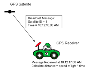
The concept is that each satellites carry very stable atomic clocks and continuously transmits a radio signal containing the current time and data about its position. Since the speed of radio waves is constant and independent of the satellite speed, the time delay between when the satellite transmits a signal and the receiver receives it, is proportional to the distance from the satellite to the receiver.

The GPS is an evolution of similar ground-based radio-navigation systems, such as LORAN and the Decca Navigator and was originally limited to use by the United States military, later opened to the civilian use even if during the 1990s, GPS quality was degraded by the United States government in a program called "Selective Availability” (finally removed on May 1, 2000).
Cold/Hot start
When the GPS has been developed the mobile networks were not yet present, so the GPS is an independent system. As said previously, each GPS Satellite transmits data about its position. This means it sends the mathematical description of its orbit to the receiver to calculate its precise position in each moment. These data are called “ephemeris” and are essential for the GPS receiver to do its internal calculation but are also used to find where the Satellite is in the sky.
When you switch on for the first time a GPS Receiver he does not know where it is, which Satellites are in view and where they are on the sky. So it starts to search them and this could be quite a long procedure, named “Cold start” and ending up when the receiver is able to detect at least 4 Satellite on the sky, to receive their “ephemeris” and to finally calculate its position. This procedure can last up to 10 minutes, especially for first time switch on, but can easily last 2-3 minutes for any switch on that happens quite far from where the switch off was done.
Viceversa, if you switch on the GPS receiver in the same position where you switch it off, the time for the fix is reduced to few seconds and this is called “Hot start”. Pay attention that if you switch on the GPS receiver in a place where no Satellites are in view (eg your garage) and you stay there for quite a long time, the GPS receiver could think to need a Cold start (because it is not able to find any Satellite).
Over time, the above “slowness” has been partially reduced with the introduction of GPS receivers with multiple “channels”, able to simultaneously search multiple Satellites at once (from the original 4-5 to the current 12-20).
GPS precision
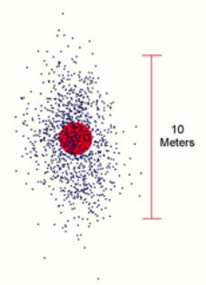
Apart during the “Selective availability” phase, when the GPS precision was degraded by the US government to around 100mt, GPS has been designed to have (in perfect Satellites visibility) around a five-meter (16 ft) accuracy with the last GPS generations aiming to few decimeters precision.
Obviously the 5mt precision is theoretical and there are many factors that can impact the GPS accuracy; to summarize we can divide these factors in 2 main categories: quality of the receiver and quality of the Satellites signal.
The quality of the receiver is an aspect that is frequently forgotten, especially for the antenna quality and positioning. If you consider a boat as an example, having a dedicated external GPS antenna on the top of the boat or using the GPS antenna in your device when below deck, can lead to very different GPS accuracies. There could also be some differences in the GPS receiver itself (eg number of channels) but in these days this component is becoming more and more standardized.
The second problem is much wider because nearly everything between the GPS receiver antenna and the Satellites impact the accuracy. Currently (for US GPS) there are 27 running Satellites so that 9 satellites are usually visible from any point on the ground at any one time, ensuring considerable redundancy over the minimum 4 satellites needed for a position. Nevertheless, considering that most of the “solid” material will stop the GPS signal, it is not uncommon to have few satellites in view especially in areas like mountains and cities and consequently with a relatively bad precision. Not only thick and solid material can cause problems to the relatively weak GPS signal but even being under the leaves or with a cloudy sky can decrease the GPS accuracy.
One problem you could have with the GPS is that, even if you are not moving (and with an overall good precision) the GPS position “moves around you”. The GPS receiver does not have any mean to understand if you are moving or not except that looking to the Satellites signal, so any fluctuation of the signals can result in calculating a different position even if you are not moving, “jumping” from one position to another (you can also have 20-30 mt jump).

In any case, to have better positions, when using a device with a GPS antenna inside, try to keep it in open sky as much as possible, avoiding to “hide” it somewhere (eg even having it in the pocket could cause to have a worse accuracy).
GPS on Mobile
Most of the current mobile devices have a GPS receiver (with antenna) inside them, but, as said previously, the GPS has been developed as an independent system; so it does not require the user to transmit any data and it operates independently of any telephonic or internet connection.
So, conceptually, the GPS receiver does not take any advantage in being on a Mobile device but the overall Localization mechanism does take advantage.
First of all, if your device is connected to internet, it can download the “ephemeris” needed to locate the GPS Satellites and inject them in the GPS receiver so to drastically reduce the Cold start (see “Cold/Hot start” paragraph).
Then, your device can use the 3G/4G/5G and the wifi networks to calculate a coarse position and “communicate” it to the GPS receiver, improving its capability to locate the Satellites on the sky and reducing the start-up phase. Using this coarse localization, the device can also reduce its power consumption (switching off the GPS receiver when not needed), improve the accuracy when GPS accuracy is bad (typically in cities were there are lot of WiFi networks) and also give some coarse localization in case the devices does not have any GPS receiver.
So, as we have seen, these additional info helps having a fast and reliable localization but keep in mind that, even in areas without any additional network, it is possible to have a good localization, just using the GPS signal.
This quick dive in the GPS technology is finished, let me recap my personal suggestions when using a GPS in your boat:
- if possible use an external antenna on the top of your boat
- when using a mobile device with internal GPS do not hide it in pockets, drawers or other “hidden” places. Keep in open sky as much as possible
- pay attention to the power consumption when the GPS is enabled, this could drain your battery
Claudio Bo, Aqua Map team.


