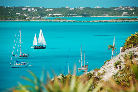
Welcome to The Bahamas...
Warm weather. Long white sandy beaches. Great sailing and terrific conch salad.
It is a cruiser’s paradise with hundreds of islands, thousands of anchorages, and a million natural treasures awaiting your discovery.
But what doesn’t The Bahamas have? Navigational aids.
Well, I mean, sometimes there is a stick with two bleach bottles and a flip-flop near a narrow channel entrance. But certainly not the kind of markers and buoys you’re used to–especially if you just cruised down the ICW before hopping over.
Bye-bye, “Red Right Returning.”
So how do you safely navigate these shallow, reef-speckled waters?
Of course, current and accurate charts and cruising guides are essential (and we’ll return to that). But another element, “reading the water,” is where true freedom and confidence come from while navigating these beautiful but notoriously skinny waters.

Trust but verify
Sandbars are ever-shifting. Grass beds rise and erode. Random coral heads jut up thirty feet tall and sit just inches below the surface—many precariously close to frequently sailed routes.
In short, the Bahamas isn’t a place where all your navigation takes place on your screen or with above-the-surface cues.
Safety, comfort, and freedom come when you can use your charts to navigate but are also confident that you can visually verify the current situation and recognize unexpected situations.
Beyond comfort, reading the water allows you to confidently work your way through narrow, winding passages, maybe allowing you to avoid a longer route.
It allows you to wiggle and nudge yourself into more protected anchorages to safely ride out approaching fronts with rare 360-degree protection. Or, it could simply allow you to freely expand your cruising grounds and explore areas far from the dotted line and well-marked anchorages.
This rings true not just in The Bahamas but in all cruising grounds where the water is clear; reading the water will enhance your safety and cruising experience.
Reading the colors
When reading the water, two factors directly affect the color of the water.
The first is what the seabed is. Is it turtle grass, scoured marl, sand, or coral? The second is how deep the water is.
You won’t learn to read the colors through pictures or a “how-to” video. Instead, it’s a learn-as-you-go experience.
Compare what you see with what your chart and depth sounder says. At first, learning is a constant trust-but-verify exercise of validating your observations with your data onboard. In time, the habit becomes second nature, and you’ll be able to instinctively notice a shifted sandbar before your keel does.
Still, let’s go over what most colors mean…
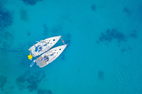
When over a dark bottom, like grass, deep water will be blue. The more inky the blue, the deeper. The more teal, the shallower. Around twenty feet, the water becomes distinctly green.
You’ll see every shade of green, so you’ll want to pay particularly close attention to dark green. It could just be a dense weed patch or shallower water. Time and experience will help you distinguish.
In green water, you want to be very aware of brown areas and avoid them. Shallow or rocky bottoms are often brown.
Yellow, orange, red, purple, or black are signs of coral. Go around. Coral heads may also have a signature light color ring around them. These are well-formed heads and often rise up great distances from the sea bottom. Again, go around.
When over a white bottom and with ultra-clear water, like on the banks or most of the Exumas, it can be incredibly difficult at first to gauge how deep the water is. It all seems super shallow. On a calm day, you can make out the orange and yellow bumps of a starfish 25 feet below!
The deeper water will be a darker blue. Once the water becomes liken to the pale shades of sea glass, it is time to start paying very close attention.
White, yellow, or colorless is too shallow to navigate. Avoid colorful patches and remain skeptical about darker patches—maybe they are just grass or a passing cloud shadow…but they may be dead coral or rocks.
Light & visually navigating The Bahamas
How well you can read the water will vary depending on sea and light conditions.
On breezy days, when there is a chop on the water, things look a bit blurry. Areas you could once easily distinguish as grass beds become unknown dark spots. It’s harder to see the colors of coral and sea fans as they mix quickly with the water’s colors.
Clouds also bring a challenge; as they pass over, you lose your ability to see through the water. Therefore, reading the water must be done in good light; it can’t be overcast or too near dawn or dusk.
The sun, ideally, will be overhead or slightly behind you. Polarized glasses are essential navigation equipment in the Bahamas. They cut the glare allowing you to see through the water.
You'll primarily depend on your electronics on cloudy, rainy, and dark days.

Explorer Charts on mobile apps & Chartplotters
Yes, you’ll feel more confident when you can read the water, but reading the water doesn’t replace the need for accurate charts. There is ONE trusted source of data in the Bahamas, the Explorer Charts.
The difference between having Explorer Chart data and not can mean having virtually no depth data at all for a harbor and having detailed depths outlining the harbor's entire contour, including shoals and hazards. Same for narrow cuts, channels, and entrances.
While Explorer Charts are available on a wide range of Chartplotters and some apps, they are not available on all—including some of the largest names in the industry. If planning to cruise The Bahamas, ensure you have access to Explorer Charts before leaving. If your Chartplotter doesn’t include Explorer Charts, a mobile navigation app that does is an ideal solution.
Aqua Map includes access to Explorer-only raster data for the best mobile navigation app in the Bahamas and can handle all the tasks of a fixed mount Chartplotter. Plus, the app is intuitive, highly customizable, and can be interfaced with your current boat systems, like your AIS. The app provides a full-functioning option for primary navigation use on a tablet or a fail-safe backup in case of damage to your boat’s GPS or electrical system.
Aqua Map Team.


